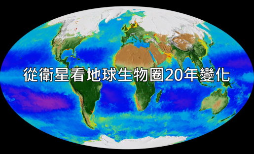
美國太空總署(NASA) 科學家與電腦專家耗時費力的將1997年9月至2017年9月從SeaStar/SeaWiFS、 Aqua/MODIS及Suomi NPP/VIIRS等遙測衛星20年來獲得的超大量陸地與海洋數據資料視覺化,變成一部2分半鐘的影片「地球生物圈20年」(20 Years of Global Biosphere (updated))從影片中可以看到地球是個活的有機體,無時無刻不變動著不呼吸著,南北極冰域隨著季節更迭而消長(也可看到南北極冰域相對消長的情形),沿岸海水(或陸地上的湖水)因人類活動及季節因素而劇烈優養化,陸地植被景觀也會隨著季節變化而不同。
影片主要呈現二類主要監控資料,一類是海水(在陸地則是湖泊)葉綠素濃度,一類是陸地植被生長情形。
藉著分析衛星收集到的反射光顏色,科學家可以知道植物光合作用強弱。植物如果生長良好,光合作用就好, 吸碳與儲碳的能力也就好。
By monitoring the color of reflected light via satellite, scientists can determine how successfully plant life is photosynthesizing. A measurement of photosynthesis is essentially a measurement of successful growth, and growth means successful use of ambient carbon. This data visualization represents twenty years’ worth of data taken primarily by SeaStar/SeaWiFS, Aqua/MODIS, and Suomi NPP/VIIRS satellite sensors, showing the abundance of life both on land and in the sea.

影片裡呈現水體的顏色,深藍到紫色表示溫暖水域且缺乏營養鹽,因此生物稀少;綠色及紅色則代表水較冷且營養鹽豐富。在沿岸地區,因為冷水從海底沿海岸湧上,帶來營養鹽,而河口地區則是河流將人類製造的各式營養鹽(如廢污水)從陸地帶進海洋。
In the ocean, dark blue to violet represents warmer areas where there is little life due to lack of nutrients, and greens and reds represent cooler nutrient-rich areas. The nutrient-rich areas include coastal regions where cold water rises from the sea floor bringing nutrients along and areas at the mouths of rivers where the rivers have brought nutrients into the ocean from the land.

影片裡呈現陸地的顏色,綠色代表豐富的植物生命,植被生長良好,如森林與草原;棕褐色及白色則是植物稀疏甚至沒有,如非洲與中東的沙漠,以及冰雪覆蓋下的極地。
On land, green represents areas of abundant plant life, such as forests and grasslands, while tan and white represent areas where plant life is sparse or non-existent, such as the deserts in Africa and the Middle East and snow-cover and ice at the poles.
以下就是NASA精心製作的地球生物圈20年觀測結果:
Credit: NASA Scientific Visualization Studio 全螢幕觀看效果更好。
影片原址:https://svs.gsfc.nasa.gov/vis/a000000/a004500/a004596/biosphere7_mollweide_1080p30.mp4
可以按右鍵下載影片作為環境教育用
這裡有另一則影片「生動的星球」 (A Candid Look at NASA’s “Living Planet”),是參與此資料視覺化的主要科學家與電腦專家的對話(有英文字幕),其中一位科學家說哈伯望遠鏡探測到宇宙至少有一、二兆個銀河,目前我們只知道地球是唯一有生命的星球,她是如此特殊與珍貴,這部影片展現了這個價值。
We know from the Hubble Space Telescope there are one to two trillion galaxies in the universe, and this only planet that we know which as life, and its very special and its very dear and this representation to me, captures that.
Credit: NASA’s Goddard Space Flight Center/LK Ward
延伸閱讀:
2020至2024年這五年中,地球將可能再創高溫紀錄(中英對照)
NASA:2017年是史上第二熱 50秒看地球138年逐漸發燒狀況(影片)
北極急速解凍 氣候問題嚴重—2017年地球發燒與北極冰況總檢視(數據、圖片、影片)-中英對照
2016年史上最熱,48秒影片看地球137年逐漸發燒狀況(含2016年全球氣候報告)