編按:
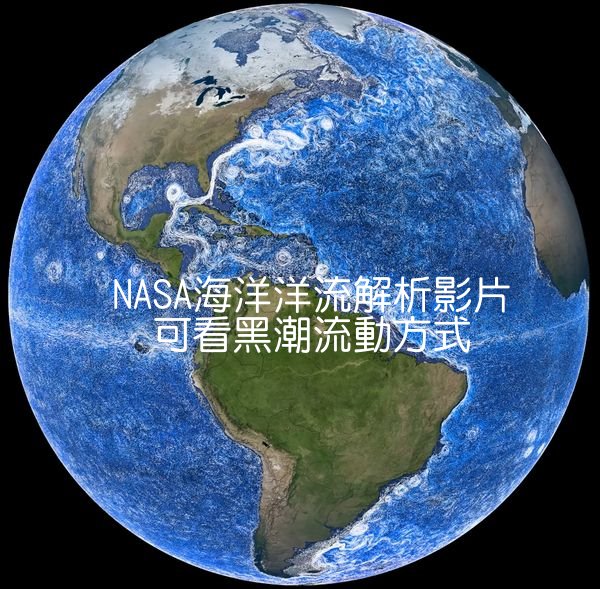
黑潮是全球第二大洋流,自菲律賓開始,穿過臺灣東部海域,沿著日本往東北向流,在與親潮相遇後匯入東向的北太平洋洋流。黑潮帶來豐富的海洋生態,有利於許多漁業發展。我們知道黑潮的重要性,但平常大都看到的是線型流向的圖說,有時很難了解細節。
美國航空暨太空總署(NASA)釋出一部影片,可以清晰看到動態的全球洋流流動方式(尤其黑潮),而且有詳細的說明,可以讓我們理解洋流流動的原理、流向,以及主要洋流對漁場、氣候調節的重要性。我翻譯英文字幕,配合影片(或擷取為圖片)可以作為海洋環教教育的素材,請參考。
流動的海洋:NASA 展現地球水下公路的迷人景象(An Ocean in Motion: NASA’s Mesmerizing View of Earth’s Underwater Highways)
海洋,永遠處於流動。整體來看,海洋盆地就像一條巨大的互聯高速公路,在全球運輸營養物質、碳和熱量。
這個令人目眩的洋流數據視覺化效果,是「海洋環流與氣候預估模型」(簡稱 ECCO)所創建的。它是由人造衛星、浮標以及各種測量數據所組成。
洋流運動的根源來自物理學原理。
由於地球自轉,水體會受到一種稱為「科里奧利效應」的影響。這股力量將一些最強勁的洋流——如墨西哥灣流和東澳大利亞洋流,推向大陸的東側。由於這些洋流最終會出現在海洋盆地的西側,科學家們將它們稱為「西邊界流」。
在這個視覺化圖像中,較接近海面的洋流呈現白色,而較深層的洋流則呈現藍色,彷彿透過水面一層層地看見深海中的流動。
但究竟是什麼驅動這些水體運動?又是什麼讓某些水上升,而某些水下沉呢?讓我們來看看!
這裡,我們可以看到太平洋最強的洋流之一——「黑潮」,它起源於溫暖的熱帶菲律賓海,然後向北流經台灣。當它到達日本後,轉向東流,穿越整個太平洋,在轉向時產生巨大的渦流。黑潮輸送的水量超過世界上最大河流——亞馬遜河的200倍!
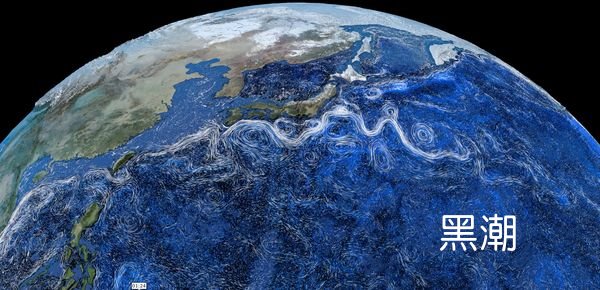
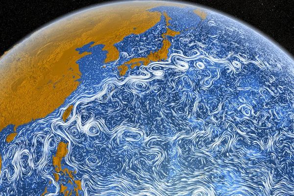
這項視覺化技術讓我們能輕鬆看見海洋如何在全球移動水體,但較難察覺的是水體上升或下沉的區域。這種現象稱為「上升流」或「沉降流」。
當上升流將寒冷、富含營養的深層海水帶到陽光普照的表層時,就會形成海洋生物的豐富食場。
部分由黑潮攜帶的營養物質,為日本的漁業提供養分,並創造了一個重要的經濟區域。
另一個重要的西邊界流是「阿古拉斯洋流」,它沿著非洲東岸一路向南流動,來到非洲最南端——「阿古拉斯岬」。在這裡,洋流急轉向東,但有時會形成巨大的漩渦,稱為「阿古拉斯環流」,它們向西漂移進入大西洋。
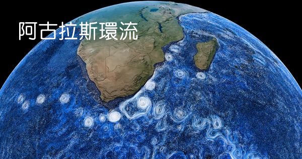
這些環狀洋流將鹽分與熱量帶入大西洋,構成全球海洋「翻轉環流」的一部分,也被稱為「全球海洋輸送帶」。
這條輸送帶系統,將熱量沿著赤道向北輸送至北大西洋,對北美、歐洲和非洲的氣候影響深遠。如果沒有這股流動,歐洲的冬季將更加寒冷,而非洲的乾旱也將更為嚴峻。
但海洋不僅僅是輸送熱量。在某些地區,它們會吸收來自太陽的熱量,而在其他地方,則會將熱量釋放回大氣。我們可以從墨西哥灣流觀察到這一點,它也是全球海洋輸送帶的一部分。
墨西哥灣流起源於熱帶地區,水溫極高,隨著洋流沿著北美洲東岸向北移動,它就像是一個為大氣加熱的「暖氣機」。當這股水流穿越大西洋,圍繞歐洲、冰島和格陵蘭流動時,水溫已經大幅下降,最終在北大西洋深處下沉。
但影響水體沉降的不僅僅是溫度, 鹽度也是關鍵因素。鹽度越高,水體就越重。當水變得更鹹、更冷時,它會變得更密集、更沉重。反之,當水變暖、變淡時,它就變得更輕。正是這些密度變化,推動著全球海洋輸送帶的循環。
在海洋表層,我們可以看到水體如何從一處移動到另一處。
如果仔細觀察,還能發現深層水體的移動方向有時與表層流向相反。
例如,在墨西哥灣流的下方,有一股寒冷的深層海流正向南流動,它也是全球海洋輸送帶的一部分,並幫助歐洲維持溫暖的氣候。
部分暖流從墨西哥灣流的表層北上,最終釋放出大量熱量,冷卻後下沉,再度向南移動。最終,這些寒冷的深層水體會逐漸擴散至全球,再慢慢上升至表層,接受陽光加熱,然後,開始新一輪的旅程。
底下配合影片時間軸,以中文對照英文字幕:
流動的海洋:NASA 展現地球水下公路的迷人景象
0:01-0:06
海洋,永遠處於流動。整體來看,海洋盆地就像一條巨大的互聯高速公路,
The oceans, they are always on the move. Together, the ocean basins are like a big interconnected highway that
0:09
在全球運輸營養物質、碳和熱量。
transports nutrients, carbon and heat around the world. This
0:14
這個令人目眩的洋流數據視覺化效果,
mesmerizing data visualization of ocean currents was created
0:18-0:22
是「海洋環流與氣候預估模型」(簡稱 ECCO)所創建的。
using a model called estimating the circulation and climate of the ocean, or ECCO, for short.
0:24-0:28
它是由人造衛星、浮標以及各種測量數據所組成。
It’s built using real world data from satellites, buoys and all kinds of other measurements.
0:33
洋流運動的根源來自物理學原理。
All of this movement starts with physics.
0:37
由於地球自轉,水體會受到一種稱為「科里奧利效應」的影響。
Because the Earth is spinning, the water feels something called
0:41-0:46
這股力量將一些最強勁的洋流——如墨西哥灣流和東澳大利亞洋流,
the Coriolis effect. This pushes some of the strongest currents, like the Gulf Stream and the East Australian Current, against
0:51-0:55
推向大陸的東側。由於這些洋流最終會出現在海洋盆地的西側,
the east side of the continents. Because these currents wind up on the west side of the ocean basins they sit in, scientists
1:00
科學家們將它們稱為「西邊界流」,
call them western boundary currents. In this visualization,
1:04
在這個視覺化圖像中,較接近海面的洋流呈現白色,而較深層的洋流則呈現藍色,
the currents closer to the surface are white and the deeper
1:08-1:12
彷彿透過水面一層層地看見深海中的流動。
currents are blue, almost like you’re seeing those deep currents through the top layer of water. But what’s causing all
1:17
但究竟是什麼驅動這些水體運動?又是什麼讓某些水上升,而某些水下沉呢?
this motion and what makes some water rise and some water sink?
1:22
讓我們來看看!這裡,
Let’s take a look. Here, we can see the Pacific Ocean’s
1:26
我們可以看到太平洋最強的洋流之一——「黑潮」
strongest current, the Kuroshio. It begins in the warm, tropical
1:30
它起源於溫暖的熱帶菲律賓海,然後向北流經台灣。
Philippine Sea, and then flows north past Taiwan. After it
1:35
當它到達日本後,轉向東流,穿越整個太平洋,
reaches Japan, it turns east and heads across the Pacific Ocean,
1:39
在轉向時產生巨大的渦流。
spinning off huge eddies where it turns right. The Kuroshio
1:44
黑潮輸送的水量超過世界上最大河流——亞馬遜河的200倍!
carries over 200 times more water than the world’s largest
1:48-1:52
這項視覺化技術讓我們能輕鬆看見海洋如何在全球移動水體,
river, the Amazon. This visualization makes it easy to see how the ocean moves water across the planet, but what’s
1:56
但較難察覺的是水體上升或下沉的區域。
hard to see are the places where the water moves up or down. This
2:01
這種現象稱為「上升流」或「沉降流」。
is called upwelling, or downwelling. When upwelling
2:05
當上升流將寒冷、富含營養的深層海水帶到陽光普照的表層時,
brings cold, deep nutrients into the sunlight near the surface,
2:09
就會形成海洋生物的豐富食場。
it creates a feeding ground for all sorts of ocean life.
2:14-2:18
部分由黑潮攜帶的營養物質,為日本的漁業提供養分,並創造了一個重要的經濟區域。
Nutrients carried, in part by the Kuroshio Current, help feed the fisheries in Japan and create an important economic
2:22
另一個重要的西邊界流是「阿古拉斯洋流」,
zone for the country. Another major western boundary current
2:27-2:31
它沿著非洲東岸一路向南流動,來到非洲最南端——「阿古拉斯岬」。
is the Agulhas Current, which carries water down the east coast of Africa to its southern tip, called Cape Agulhas. There,
2:35-2:40
在這裡,洋流急轉向東,但有時會形成巨大的漩渦,稱為「阿古拉斯環流」,
the current makes a sharp turn to the east, but sometimes it pinches off giant eddies called the Agulhas rings, which drift
2:44
它們向西漂移進入大西洋。
west into the Atlantic. These circular currents carry salt and
2:49-2:53
這些環狀洋流將鹽分與熱量帶入大西洋,構成全球海洋「翻轉環流」的一部分,也被稱為「全球海洋輸送帶」。
heat into the Atlantic and form an important part of the overturning circulation, also called the Global Ocean conveyor
2:58-3:02
這條輸送帶系統,將熱量沿著赤道向北輸送至北大西洋,
belt. This so called conveyor belt is a system of currents that carries heat northward, across the equator and into the
3:06-3:11
對北美、歐洲和非洲的氣候影響深遠。如果沒有這股流動,
North Atlantic. It plays a big role in the climates of North America, Europe and Africa. Without it, winters in Europe
3:15
歐洲的冬季將更加寒冷,而非洲的乾旱也將更為嚴峻。
would be much colder, and droughts in Africa more severe.
3:19
但海洋不僅僅是輸送熱量。
But the oceans do more than just move heat around. In some
3:23-3:28
在某些地區,它們會吸收來自太陽的熱量,而在其他地方,則會將熱量釋放回大氣。我們可以從墨西哥灣流觀察到這一點,
places, they absorb heat from the sun, and in others, they release it back to the air. We can see that in the Gulf Stream,
3:32
它也是全球海洋輸送帶的一部分。
yet another part of the ocean’s conveyor belt, the Gulf Stream
3:37
墨西哥灣流起源於熱帶地區,水溫極高,
starts in the tropics, where the water is very warm, as it drags
3:42
隨著洋流沿著北美洲東岸向北移動,
warm water up the east coast of North America, it acts like a
3:46
它就像是一個為大氣加熱的「暖氣機」。
heater for the atmosphere. By the time this water has wandered3:51
當這股水流穿越大西洋,圍繞歐洲、冰島和格陵蘭流動時,
across the Atlantic and wrapped around Europe, Iceland and
3:55
水溫已經大幅下降,最終在北大西洋深處下沉。
Greenland, it’s gotten so cold that it sinks deep into the
3:59
但影響水體沉降的不僅僅是溫度,
North Atlantic Ocean. But temperature isn’t the only thing
4:03-4:08
鹽度也是關鍵因素。鹽度越高,水體就越重。當水變得更鹹、更冷時,
that can make water sink, so can salt. Salinity or the amount of salt in the water, can make it heavy. The saltier and colder
4:12
它會變得更密集、更沉重。反之,當水變暖、變淡時,它就變得更輕。
water is, the heavier it gets. As it gets warm and fresh water
4:17
正是這些密度變化,
gets lighter, changes in the heaviness or density of ocean
4:21
推動著全球海洋輸送帶的循環。
water are what keep the ocean’s conveyor belt turning. Streaks
4:26
在海洋表層,我們可以看到水體如何從一處移動到另一處。
near the surface show how water is moving from one place to
4:30-4:34
如果仔細觀察,還能發現深層水體的移動方向有時與表層流向相反。
another. If you look close, you can see below the surface. Sometimes the water down deep is moving in a different direction,
4:39-4:44
例如,在墨西哥灣流的下方,有一股寒冷的深層海流正向南流動,
even the opposite direction. Sometimes this cold, deep water headed south beneath the Gulf Stream is another part of that
4:48
它也是全球海洋輸送帶的一部分,並幫助歐洲維持溫暖的氣候。
same ocean conveyor belt that keeps Europe warm. Some of that
4:53
部分暖流從墨西哥灣流的表層北上,
warm Gulf stream water that heads north at the surface
4:57-5:01
最終釋放出大量熱量,冷卻後下沉,再度向南移動。最終,這些寒冷的深層水體
eventually winds up there, moving south again after losing so much heat to the atmosphere. Eventually this cold, deep water
5:06-5:10
會逐漸擴散至全球,再慢慢上升至表層,接受陽光加熱,
will spread around the globe and slowly rise toward the surface. There it will warm up in the sun and get ready to start the trip
5:15
然後,開始新一輪的旅程。
all over again.
我另外張貼「日本海洋生物多樣性」網頁介紹黑潮的文字如下:
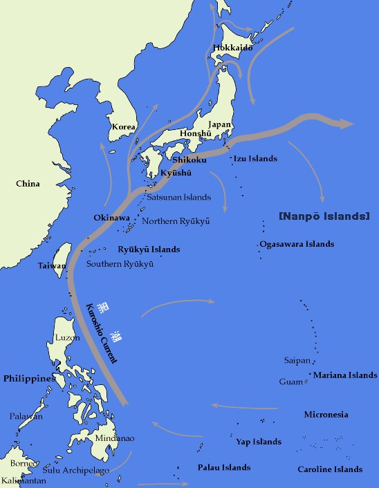
流經日本列島的主要洋流共同維繫著該區域的生物多樣性,使此處成為全球冷溫帶與暖溫帶海洋生物最豐饒且物種多元的海域之一。這項自然優勢不僅造就日本漁業的強盛根基,更孕育出絕佳的潛水環境,成為需要靜心體會與悠閒探索的水中活動理想場域。
其中,黑潮與親潮洋流系統對日本水域生態環境影響最為顯著。這股洋流不僅帶來溫暖水溫與高透明度,更孕育出珊瑚礁群與豐富的生物多樣性。該洋流系統的間接效應還包含強勁的沿岸湧升流現象,配合日本獨特複雜的火山海底地形與部分海域的深水通道,將富含營養的深層冷水推送至表層水域,連帶使罕見的深海生物現蹤此處……
觀察黑潮的路徑,其源頭始於「西太平洋暖池」區域,具體來說,是來自太平洋的北赤道洋流,此洋流先沿赤道向西流動,之後轉向菲律賓,穿越東南亞東側極具生物多樣性的「珊瑚大三角」地區——換句話說,也就是穿越全球主要海洋生物多樣性中心之一——再向北流向日本列島……此乃琉球群島珊瑚礁區能成為全球重要多類群特有種分布中心的原因之一。
日本海域的季節性溫差與洋流變化,更引發大規模產卵育幼與覓食活動,同時驅動海洋哺乳類的遷徙行為。每年寒季時分,大翅鯨、抹香鯨、領航鯨等鯨類便會循此路徑現蹤於日本沿海水域。
延伸閱讀:
人與生物圈雜誌刊登邵廣昭老師文章《用保護區挽救海洋生物多樣性》
世界氣象組織《2024年全球氣候報告》摘要-可當環境教育素材
紅得發黑:2024年6月中下旬全球熱爆圖(影片)-可作環境教育素材
氣候變遷效應:2023年是氣候新紀錄年(中英對照、有報告可下載)
歐盟2040年氣候目標依賴不確定技術——碳捕獲和封存技術尚不成熟(中英對照)
氣候變遷實境SHOW-3-地球的退燒藥配方(斯創教育工作群撰)
氣候變遷實境SHOW-2-地球真的發燒了(斯創教育工作群撰)

